MGP Map
The MGP Map is interactive. Think of it as Google Maps for MGPs. You control what you want to see.
Instructions
Basics
If you can find a restaurant on Google Maps, you can use this Map.
- The MGP Map always opens in a new window.
- Zoom and Home are in the upper left.
- Pan with your touchscreen or click and drag.
- Map Layers and Basemaps are in the upper right.
- Turn on one layer at a time until you understand that layer

First Time Users
Get familiar with the controls.
- Find the home button in the upper left. Zoom, pan, and return to home.
- Find the Basemap Gallery in the upper right. Click the icon (four squares) to see the drop down menu. Click on the thumbnails and zoom, pan, and return to home with different basemaps. You’ll notice that some basemaps and some layers have a limited zoom range. That’s normal. While exploring here, click the four squares icon again several times and notice the drop-down menu will appear when you want it and disappear when you don’t want it.
- Find the Map Layers in the upper right. Click the icon (a file folder) to see the drop down menu. Find the Background section towards the bottom. Click the check-box next to “MGPs” and the pinkish MGP layer will disappear. Click again and it reappears. Repeat until you get used to turning layers on and off. Scroll down in the Background section and find “All Parcels.” Click that check-box a few times. Zoom, pan, change basemaps, etc., while doing this. You’ll discover that all the controls are independent. Click the words “Testing” or “Parcels” or “Background” and that section will collapse or expand for better visibility of the layers you want to access.
- There are more controls but you are ready to explore on your own. Remember to turn on one layer at a time until you understand that layer. For interest and to get more comfortable with the controls, you may want to continue looking at different layers in the Background section. Hints: Different basemaps are useful for different perspectives. The Oceans basemap has the least clutter which can make it useful to see what you are looking at. When you are somewhat comfortable with the controls, try using the transparency sliding scale (three dots near the check-box) with the “San Francisco 1859” layer. You’ll see how the City expanded its borders. MGP contamination is found mostly near the bay margins; explore it through the layers in the Testing and Parcels sections.
Drill Down
Additional information can be accessed directly from the Map. Just as you can get the menu and hours for the restaurant you’ve located on Google Maps, you can summon a variety of useful facts while using the MGP Map. Most objects on the Map have buried information.

- Click on any point on the Map and you’ll see a pop-up box. Look at the grey bar on top of the pop-up, it will tell you the number of map layers that were present at the point you clicked. If there are a large number of layers, you are probably zoomed out too far to be useful. Zoom in closer and try clicking again.
- When you have what you want in view, the number in the grey bar will match the number of boxes checked in the Map Layers menu. If there are still too many, uncheck some boxes to focus on a few topics of interest. Use the small arrowhead in the grey bar to step through the pop-ups. The information in each pop-up box pertains to the object currently highlighted by a light aquamarine border.
- The information in the pop-up is shorthand. You’ll learn to read it with a little use.
- Many pop-up boxes have “more info” highlighted as a live link. Click it and a new window opens with additional information about the object. The new window, in turn, often has more live links to drill further down. This allows you to drill down as far as desired. For some, the ultimate goal is to reach the source documents.
Three Viewpoints
The Map has three fundamental ways to look at MGP contamination in the Marina and Fisherman’s Wharf:
- Testing, which shows where contamination has been found.
- Parcels, which shows the impact of contamination on properties … and on neighbors.
- Warnings, which is the story of missed opportunities.
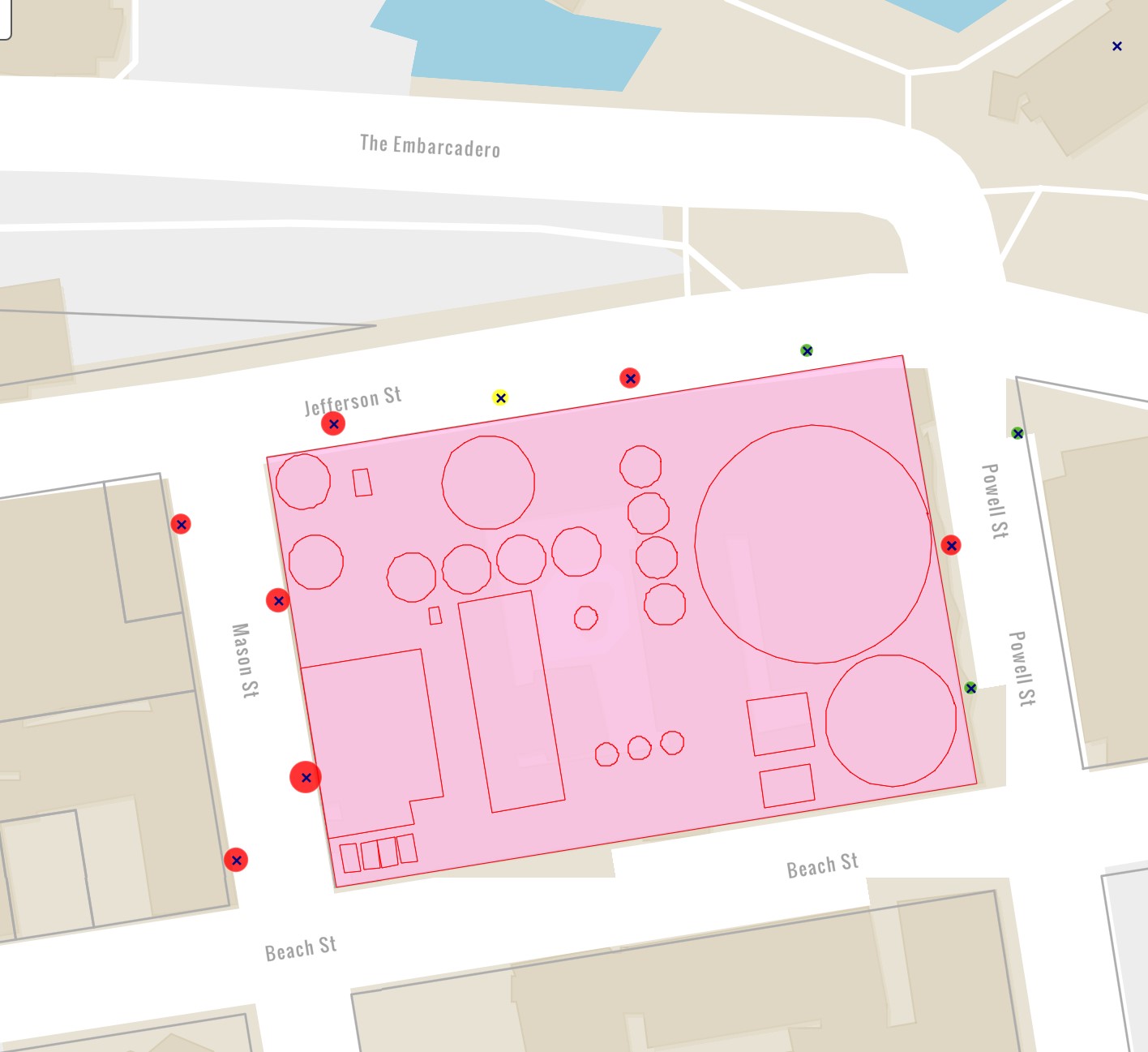
1. Testing
- The location of the test sample is a point at the center of the x. The type of test (soil, groundwater, etc.) determines the symbol (circle, square, etc.).
- The concentration of the chemical is indicated both by color and by size as determined by screening levels.
- NOTE: samples are considered points that have no dimension. The size of the symbol indicates the relative strength of the chemical found at that point. It does not represent the spread of the chemical. (To see the points connected into areas, refer to the heat maps in the “Background” section of this website.)
- Green is good. Yellow will not trigger a clean-up but if a clean-up does occur all yellow will be removed. No single data point will trigger action. Instead, judgments are made using multiple data points and are dependent on other factors as well.
- CAVEAT: The viewer should be aware that testing is sparse in many areas. It is impossible to confirm the absence of contamination in areas that do not have a large number of test points. Even when there are a large number of test points in an area, if the testing has been of only one type it may not be possible to confirm the absence of contamination.
- All samples displayed on the Map are live objects. Click them to see a pop-up with details.
- Remember to turn on one layer at a time until you understand it.
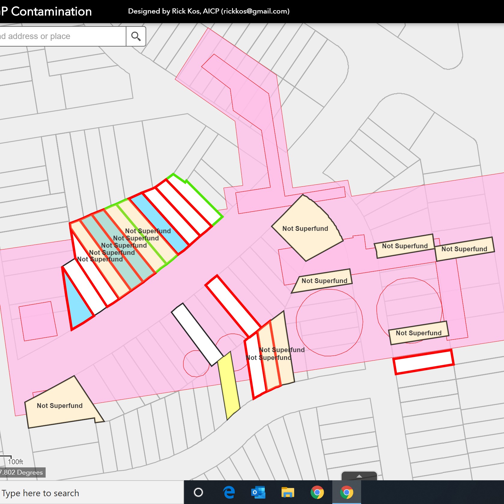
2. Parcels
- To see the impacts clearly, zoom in to an area no larger than a few city blocks.
- If necessary, the color coding can be seen by clicking the small black arrow next to the check-boxes.
- While in this view, toggle the Not Superfund check-box in the Background group. This gives a then-and-now view of MGP investigations.
- Layers overlap and colors blend, stay aware of the number of boxes checked. Reduce the number of layers until you understand what you are seeing.
- Every parcel with public domain information relating to MGPs has a pop-up with “more info.” Follow the links to see a summary for the parcel and, if desired, drill down further to find source documents.
- For an overall summary, a tally of the number of parcels in each category can be found under Outcomes on the Project page of this website. The number and status of parcels is expected to change over time as individual parcels move through the pipeline.
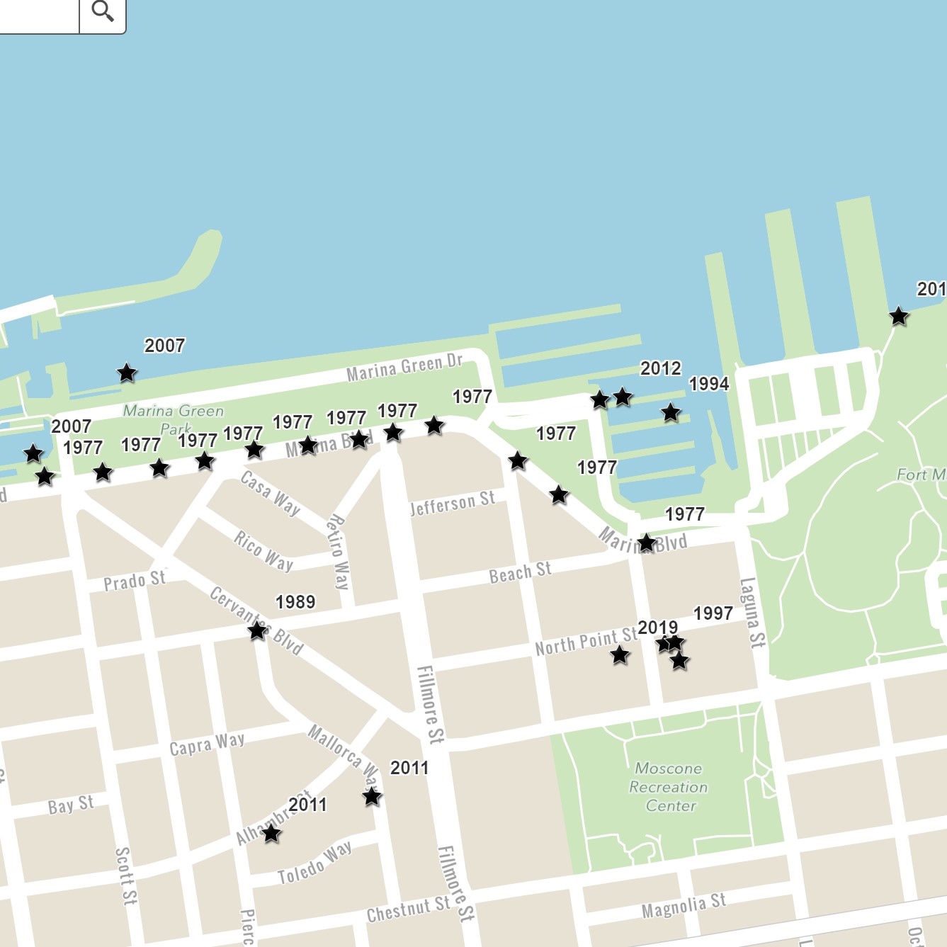
3. Warnings
- The first signs of “extensive” contamination in the area occurred 40 years ago. There have been a number other signs since.
- About half the discoveries occurred during investigations that were not looking for contamination but happened to find creosote, a telltale sign of MGP contamination.
- The black star indicates the location, the year is when the discovery was made.
- All warnings have a pop-up with a link for “more info.” Follow the link to learn more about each warning.
- To learn the story of missed opportunities, click through the warnings in any order. You’ll see a brief summary in the pop-up and, if desired, you can follow the more info down to the source documents.
- One set of particularly egregious missed opportunities is described in the Inquiry page located on this website.
Definitions
Top of list
1986P 1986 protocol. Shallow soil testing used in the Not Superfund project
APN Assessor’s Parcel Number. See parcel
B(a)P-EQ Benzo A Pyrene equivalent. A commonly used measure for the concentration of PAHs in soil
BCH Beach Street MGP, in Fisherman’s Wharf
bgs below ground surface
Black Rocks A solid form of MGP contamination
CAN Cannery MGP, in Fisherman’s Wharf
CERCLA Comprehensive Environmental Response, Compensation, and Liability Act. Commonly Superfund
CERCLIS Information system associated with CERCLA
Coal tar A byproduct of the MGP process, a liquid form of MGP contamination
contamination A material with chemical concentrations exceeding government guidelines
Creosote A derivative of coal tar. Related to NAPL, SPR, and Product.
FIL Fillmore MGP, in the Marina
four MGPs BCH, CAN, FIL, and NOB
Lagoon An area in the Marina between c 1895 and c 1914, filled before the 1915 PPIE
LUC Land Use Covenant
MGP Manufactured Gas Plant
MGPdata URL for this website. Also parcels that have a public record with MGP content
NAPL Non-aqueous phase liquid, a technical term. Related to creosote, SPR, Product, and coal tar
NOB North Beach MGP, in the Marina
Not Superfund A project in the 1980s that determined the four MGPs were not Superfund sites
NPL National Priorities List, part of Superfund
PAH Polynuclear Aromatic Hydrocarbons. A class of chemical compounds associated with MGPs.
parcel A plot of land recognized by the assessor recorder
PG&E Pacific Gas and Electric Company and PG&E Corporation
Product Term of art used for NAPL, SPR, coal tar, etc.
SFG San Francisco Gas Company, a predecessor to SFGL
SFG&E San Francisco Gas and Electric Company, a predecessor to PG&E
SFGL San Francisco Gas Light Company, a predecessor to SFG&E
SPR Separate Phase Residual, a technical term. Related to NAPL, creosote, Product, and coal tar.
Superfund site A site on the NPL
Superfund Common term for CERCLA
TBD To Be Determined
TPAH Total PAHs, a sum
VMS Vapor Management System
Bottom of list